

Gps
Summary
Frends offers seamless integration with GPS, allowing you to easily connect to and automate data flows involving Global Positioning System data for precise, efficient location and timing information.
Frends provides tasks for performing core GPS data operations and coordinate processing.
By leveraging Frends' task-based approach, you can configure and customize GPS integrations to match your exact spatial data needs. Frends supports a wide range of integrations to various systems and protocols, making GPS data part of a larger automation strategy.
Use cases
Below you will find typical use cases for GPS integrations and how they are implemented in Frends.
Transform Gdal
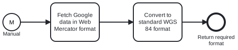
Use Frends TransformGdal task to process raw GPS data and perform GDAL-based transformations, allowing you to convert coordinate systems, reproject spatial data, and ensure compatibility across different mapping platforms.
Categories

All Tasks
TransformGdal1.0.0